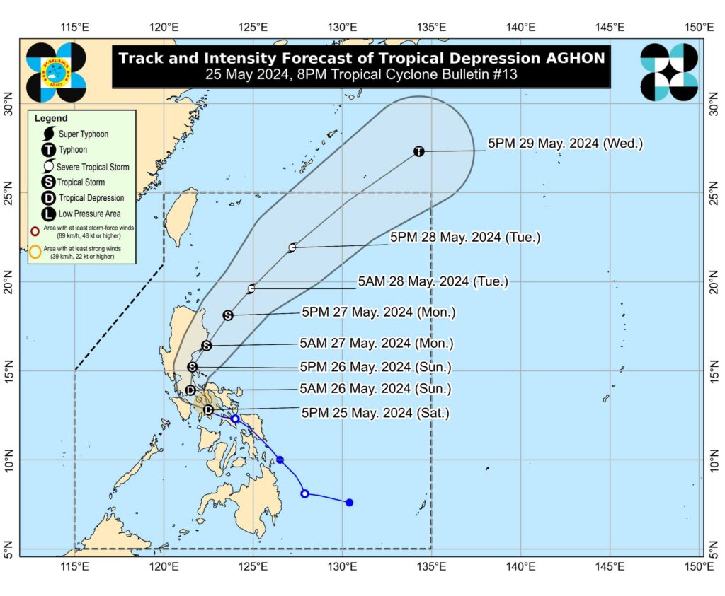
Tropical Depression Aghon, the first tropical cyclone to enter the Philippines in 2024, has been making headlines as it traverses the country, bringing heavy rainfall, strong winds, and the potential for flooding and landslides.
As Aghon continues its path, it is crucial for residents to stay informed about the latest developments and take necessary precautions to ensure their safety.
Aghon’s Current Status and Projected Path
As of the latest update from the Philippine Atmospheric, Geophysical, and Astronomical Services Administration (PAGASA), Tropical Depression Aghon was located over the coastal waters of Sibuyan Island, moving west-northwestward at a speed of 30 kilometers per hour (km/h).
The tropical depression has slightly weakened, with maximum sustained winds of 45 km/h and gustiness of up to 70 km/h.
Aghon is forecast to move generally northwestward over the Sibuyan Sea and Tayabas Bay, potentially making landfall over Marinduque within the next 12 hours. During this period, the possibility of Aghon further weakening into a low-pressure area is not ruled out.
After passing through Marinduque, Aghon is expected to move upward and possibly make another landfall in Quezon, either in Lucena City or Pagbilao, before emerging over Lamon Bay by Sunday morning, May 26.

Areas Under Tropical Cyclone Wind Signals
PAGASA has raised Tropical Cyclone Wind Signal (TCWS) No. 1 over several areas in Luzon, including:
- Northern portion of Aurora (Casiguran, Dilasag)
- Polillo Islands
- Southern portion of Quezon (Calauag, Guinayangan, Lopez, Buenavista, Catanauan, Mulanay, San Narciso, San Francisco, San Andres, Tagkawayan, Gumaca, Quezon, Alabat, Perez, Plaridel, Pitogo, Macalelon, General Luna, Atimonan, Unisan)
- Eastern portion of Romblon (Cajidiocan, Magdiwang, San Fernando)
- Camarines Norte
- Camarines Sur
- Catanduanes
- Albay
- Sorsogon
- Masbate including Burias and Ticao Islands
In the Visayas, TCWS No. 1 is in effect over:
- Northern Samar
- Samar
- Eastern Samar
- Biliran
- Leyte
- Southern Leyte
- Extreme northern portion of Cebu (San Remigio, Tabogon, City of Bogo, Medellin, Daanbantayan, Borbon) including Camotes and Bantayan Islands
Dinagat Islands in Mindanao is also under TCWS No. 1.
Expected Rainfall and Potential Hazards
Aghon is expected to bring heavy rainfall over several regions, which may trigger flooding and landslides, especially in areas highly susceptible to these hazards. PAGASA’s rainfall forecast from Saturday noon, May 25, to Sunday noon, May 26, includes:
- 100-200 millimeters (mm): Quezon including Polillo Islands, the eastern part of Laguna, the eastern part of Rizal, Marinduque, Romblon, Bicol
- 50-100 mm: Eastern part of Isabela, Aurora, Metro Manila, the rest of CALABARZON, Oriental Mindoro, Occidental Mindoro, and the northern portion of Western Visayas
Residents in affected areas are advised to take precautionary measures, monitor updates from local authorities, and be prepared for possible evacuation if necessary.
Government Response and Preparedness Measures
The Department of Social Welfare and Development (DSWD) has alerted its field offices in Eastern Visayas, Bicol, and Caraga to check their inventories of family food packs as part of the preparations for the potential impact of Aghon.
DSWD Secretary Rex Gatchalian assured that the agency has prepositioned over P189 million worth of food packs in areas under TCWS No. 1, with additional stockpiles in the National Resource Operations Center in Pasay City and the Visayas Disaster Resource Center in Cebu City.
Local government units and disaster risk reduction and management offices in affected regions have also been implementing preparedness measures, such as activating emergency response protocols, conducting pre-emptive evacuations in high-risk areas, and ensuring the readiness of relief goods and rescue equipment.
As Tropical Depression Aghon continues to affect various parts of the Philippines, it is essential for residents to remain vigilant, stay updated with the latest information from reliable sources, and follow the advice of local authorities.
By working together and prioritizing safety, communities can minimize the potential impacts of Aghon and bounce back stronger in the face of this natural hazard.
Remember, in times of calamities, it is the spirit of bayanihan that will help us weather the storm. Stay safe, stay informed, and let us look out for one another as we navigate through these challenging times.


Your comment is awaiting moderation.
You have remarked very interesting details ! ps decent web site.